


US Topo Maps
Opis US Topo Maps
Łatwa w użyciu aplikacja do nawigacji zewnętrznej z bezpłatnym dostępem do najlepszych dostępnych map i zdjęć lotniczych dla USA.
Wybieraj spośród ponad 30 warstw map (topos, anteny, mapy morskie, ...), aby zaplanować idealną podróż i
zamień swój telefon/tablet z Androidem w zewnętrzny GPS, aby móc podróżować offline w backcountry.
Dodaj łatwo mapy z innych źródeł (GeoPDF, GeoTiff, usługi map online, takie jak WMS, ...)
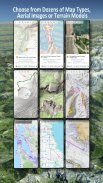
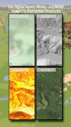
Dostępne warstwy mapy bazowej dla USA:
• Topo mapy krajowej USGS
• Topo zdjęć mapy krajowej USGS
• Zdjęcia mapy krajowej USGS
• Zdjęcia USGS NAIP HiRes
• Tradycyjne grupy DRG USGS Topo: Bezproblemowe pokrycie map topograficznych USA w skalach 1:250 000, 1:100 000, 1:63 000 i 1:24 000/25 000
• Mapy lasów FSTopo
• Mapy morskie NOAA RNC
• Krajowe mapy wysokości (cień wzgórza, mapa zboczy, mapa aspektów)
Warstwy mapy bazowej całego świata:
• OpenStreetMaps (5 różnych układów map), można również pobrać w formacie wektorowym oszczędzającym miejsce
• Mapy Google (zdjęcia satelitarne, mapy drogowe i terenowe)
• Mapy Bing (zdjęcia satelitarne, mapy drogowe)
• Ziemia Nocą
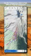
Skonfiguruj warstwę mapy bazowej jako nakładkę i użyj suwaka przezroczystości, aby płynnie porównywać mapy ze sobą.
Dodaj mapy z innych źródeł:
• Importuj mapy rastrowe w GeoPDF, GeoTiff, MBTiles lub Ozi (Oziexplorer OZF2 i OZF3)
• Dodaj usługi mapowania sieciowego jako WMS lub WMTS/Tileserver
• Importuj OpenStreetMaps w formacie wektorowym, np. całe USA za kilka GB
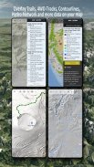
Dostępne nakładki na mapy USA - dodaj dodatkowe informacje do dowolnej innej mapy bazowej:
• Publiczna własność gruntów (PAD-US 3)
• Krajowy Zbiór Danych Hydrograficznych
• Mapa użytkowania pojazdów silnikowych (USDA)
• Kontury elewacji
• Trasy z napędem na 4 koła
• Szlaki
• Drogi, linie kolejowe, lotniska
Dostępne na całym świecie nakładki:
• Nakładka cieniująca wzgórze
• Kontury 20 m
• OpenSeaMap
Nie ma mapy idealnej. Przełączaj się pomiędzy różnymi warstwami map lub korzystaj z funkcji porównywania map, aby znaleźć najciekawszą trasę. Zwłaszcza stare, tradycyjne grupy DRG zawierają wiele małych ścieżek lub innych elementów, których brakuje na współczesnych mapach.
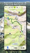
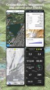
Główne cechy nawigacji zewnętrznej:
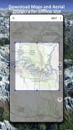
• Pobierz dane map do użytku w trybie offline
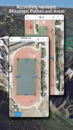
• Mierz ścieżki i obszary
• Twórz i edytuj punkty trasy
• Nawigacja GoTo-Waypoint
• Twórz i edytuj trasy
• Nawigacja po trasie (nawigacja od punktu do punktu)
• Rejestracja trasy (z profilem prędkości, wysokości i dokładności)
• Tripmaster z polami na licznik przebiegu, średnią prędkość, namiar, wysokość itp.
• Import/eksport GPX/KML/KMZ
• Wyszukiwanie (nazwy miejsc, POI, ulice)
• Uzyskaj wysokość i odległość
• Konfigurowalne pola danych w widoku mapy i Tripmaster (np. prędkość, dystans, kompas, ...)
• Udostępniaj punkty trasy, ślady lub trasy (przez e-mail, Dropbox, WhatsApp, ..)
• Użyj współrzędnych w WGS84, UTM lub MGRS/USNG (siatka wojskowa/sieć krajowa USA),
• Powtórka utworu
• i wiele więcej ...
Używaj tej aplikacji nawigacyjnej do aktywności na świeżym powietrzu, takich jak wędrówki, jazda na rowerze, biwakowanie, wspinaczka, jazda konna, narciarstwo, spływy kajakowe, polowania, wycieczki na skuterach śnieżnych, wycieczki terenowe z napędem na 4 koła lub akcje poszukiwawczo-ratownicze (SAR).
Dodaj własne punkty trasy w formacie długości/szerokości geograficznej, UTM lub MGRS/USNG z punktem odniesienia WGS84.
Importuj/eksportuj/udostępniaj punkty/ślady/trasy GPS w formacie GPX lub Google Earth KML/KMZ.
Zobacz animowany radar opadów NEXRAD, aby dokładnie przewidzieć, kiedy zacznie się/przestanie padać
Pytania, komentarze i prośby o nowe funkcje prosimy przesyłać na adres support@atlogis.com
US Topo Maps - Wersja 7.8.0
(08-05-2025)US Topo Maps - Informacje APK
Wersja APK: 7.8.0Pakiet: com.atlogis.northamerica.freeNajnowsza wersja US Topo Maps
Inne wersje


Apki w tej samej kategorii

Mogą Cię się spodobać...


